LAKE COUNTY, Calif. — The Board of Supervisors on Tuesday held the fourth in a series of public hearings on the county supervisorial redistricting process, directing staff to bring back a resolution to adopt the final map.
The process takes place every 10 years following the release of the data from the U.S. Census Bureau.
The county process, which redraws the five supervisorial districts, is separate from the California Citizens Redistricting Commission’s ongoing efforts to delineate new state Assembly and Senate, and congressional districts.
Consultant Margaret Long told the board that the law requires at least four public hearings be held.
The first, held during the board’s regular Aug. 31 meeting, was to explain the process. A special stand-alone meeting on Saturday, Oct. 2, focused on communities of interest, while the third, held on the evening of Nov. 2, went over the maps and resulted in a recommendation for the final map.
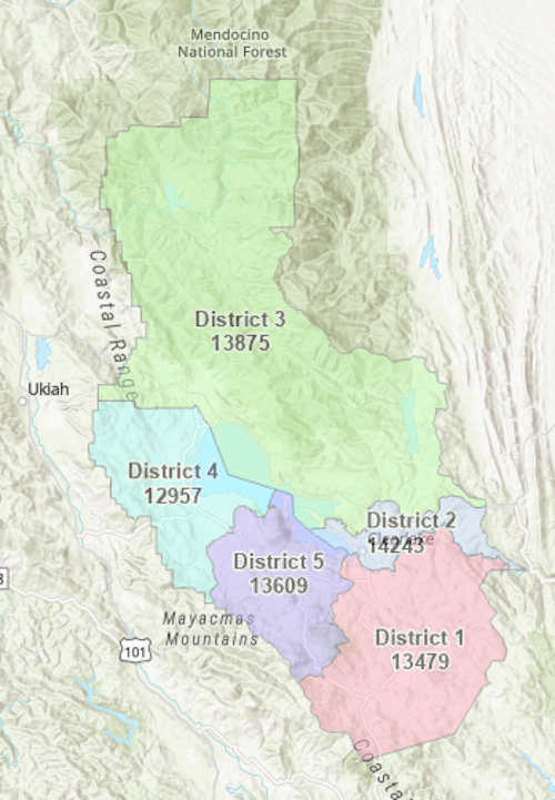
Long said the final map proposed from the options offered to the board is No. 6, which she said incorporates all of the changes and recommendations from the supervisors and the public.
She said the option No. 6 map meets all legal requirements, including all districts being contiguous and within a 10% population deviation.
Each district should have 13,633 residents or be within 10% of that number. Option No. 6 places the population in the five districts as follows: District 1, 13,479; District 2, 14,243; District 3, 13,875; District 4, 12,957; and District 5, 13,609.
The new district boundaries would differ from the current boundaries as follows, based on the description placed on the option No. 6 map:
• In North Lakeport, the area bounded by Highway 29, the Nice-Lucerne Cutoff and Rodman Slough would be moved from District 3 to District 4 in order to move all of the contiguous tribal lands in that area into a single district.
• A small area east of Big Canyon Road at Ettawa Springs Rd has moved from District 1 to District 5 in order to keep as much of the Cobb Area Council within a single district.
• In the city of Clearlake, the census blocks south of Lakeshore Drive have been moved from District 1 to District 2 in order to keep the central business corridor along Lakeshore Drive within a single district, and the area south of Dam Road has been moved to District 1.
• Riviera Heights subdivision west to Lakeview Estates Drive has been moved from District 4 to District 5 to keep all of “The Rivieras” communities in a single district.
• North of Kelseyville, the area bounded by Kelsey Creek, Soda Bay Road and Clear Lake State Park has been moved from District 4 to District 5.
Based on the discussion and the options Long presented, the board chose to direct staff to bring back a resolution accepting the new map and emphasizing the use of census blocks, which will save time and allow the county to meet the Dec. 15 deadline.
The county’s GIS expert, Lon Sharp — who also was part of the redistricting effort in 2011 — told the board that using the county’s 2,900 census blocks is the easiest method, explaining that he could have a list of the census blocks for each proposed district by the end of the day if needed.
County Counsel Anita Grant also supported using census blocks and suggested that the resolution should include the maps if possible. It’s the legitimate way to go, she added, and can be done clearly and efficiently.
“The map was built on census blocks so it makes perfect sense to just use census blocks,” said Board Chair Bruno Sabatier.
Sabatier agreed that a resolution is the appropriate way to move forward, and that since the board has held four hearings, it didn’t need to go through a process that included a first and second reading of the final map approval document.
With the consensus of the board, Sabatier directed staff to come back with the resolution to accept the map and thanked the staff involved, which in addition to Sharp included Deputy Administrative Officer Matthew Rothstein.
All of the maps can be found on the county’s website.
Email Elizabeth Larson at This email address is being protected from spambots. You need JavaScript enabled to view it.. Follow her on Twitter, @ERLarson, or Lake County News, @LakeCoNews.
"direct" - Google News
December 02, 2021 at 05:26PM
https://ift.tt/3EiOzeV
Supervisors choose final redistricting map, direct staff to bring back resolution - Lake County News
"direct" - Google News
https://ift.tt/2zVRL3T
https://ift.tt/2VUOqKG
Direct
Bagikan Berita Ini


0 Response to "Supervisors choose final redistricting map, direct staff to bring back resolution - Lake County News"
Post a Comment