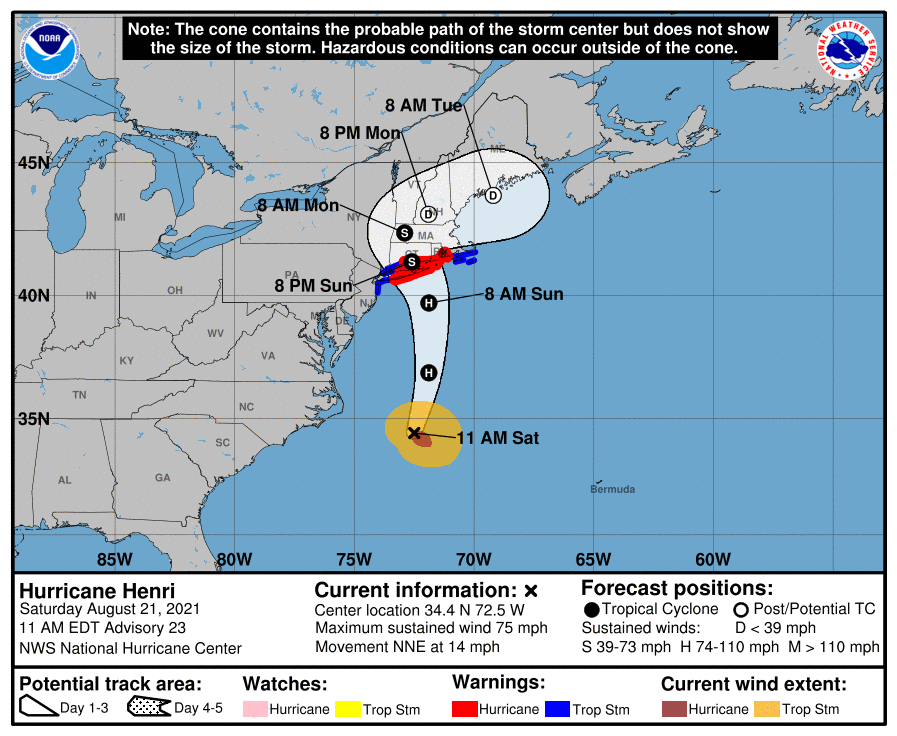
Henri strengthened to a Category 1 hurricane Saturday morning and continued to take aim at Connecticut, staying on course for an expected direct hit on Sunday morning.
A hurricane warning remains in effect for parts of Connecticut with storm surge along the coast expected to reach up to 3-5 feet. Henri did not shift off course through the night, continuing on the western swing that puts the state in its direct path.
A storm becomes a Category 1 hurricane when its winds exceed 74 miles per hour. As of 11 a.m. Saturday, Henri had 75 mph winds, according to the National Weather Service.
Henri is expected to bring high winds, torrential rains and a significant risk of shore and inland flooding. Eversource officials said Saturday that 50-69 percent of its 1.25 million customers could lose power for 8-21 days. United Illuminating, the power company that serves the Bridgeport and New Haven areas, did not estimate outages.
The power companies faced significant criticism for their responses to last year’s Tropical Storm Isaias, when about 750,000 customers lost power for as long as a week.
While Sunday morning should see some rain and wind, the worst is expected to reach Connecticut by the afternoon. Forecasters said the storm will move slowly once it reaches land.
No area of the state is expected to escape impact. Initial projections were that Henri would affect New Haven and east the most, but the storm's western shift puts residents in and around Greenwich, Stamford, Norwalk, Bridgeport, and Danbury in its path.
Storm Watch
More Henri Coverage
The National Weather Service issued a hurricane warning for Northern Middlesex, Northern New Haven and Northern New London counties. A storm surge and hurricane warning are in effect for southern Middlesex, southern New Haven and southern New London counties.
A storm surge and tropical storm warning was issued for southern Fairfield County. The weather service issued just a tropical storm warning for the northern part of Fairfield County.
Eversource’s estimates are from the University of Connecticut and Eversource Energy Center’s Outage Prediction Modeling group.
The group is predicting a “high impact” in each town, according to Diego Cerrai, the team leader for the Outage Prediction Model group and an assistant professor of the University of Connecticut’s Department of Civil and Environmental Engineering.
Cerrai compared the storm’s impact to Hurricane Isaias, which put 500,000 Eversource customers without power last year.
All of Connecticut’s shoreline is under a storm surge watch, meaning “there is a possibility of life-threatening inundation, from rising water moving inland from the coastline," the National Weather Service said.
Dan Warzoha, the emergency management director for Greenwich, said “This could be the biggest storm event that we’ve seen since Superstorm Sandy,” and possibly Hurricane Bob in 1991.
Gov. Ned Lamont declared a civil preparedness emergency and requested President Biden declare a state of emergency for federal assistance to help with storm damage. Lamont also called for 200 members of the National Guard to be prepared to conduct search-and-rescue missions, as well as clear routes, help with power and distribute goods if needed. Lamont met by phone with Biden and area governors on Saturday.
Lamont said he was cutting short his Maine vacation to return to the state.
New Haven Mayor Justin Elicker Saturday advised some residents to evacuate low-lying areas of the city Saturday afternoon, as Hurricane Henri headed “straight towards us.”
Elicker said the city was now expecting three for five feet of storm surge and four to six inches of rain, an increase from what was predicted yesterday afternoon.
The town of Madison issued a mandatory evacuation for all residents south of the Boston Post Road. Those residents must evacuate by 9 p.m. Saturday.
Groton, a city along the shoreline, recommended a voluntary evacuation starting at 10 p.m. Saturday for some of its residents.
The city, in partnership with the Red Cross, will be opening a shelter at Fitch High School, 101 Groton Long Point Rd., starting Saturday at 6 p.m. People wishing to stay in the shelter should bring pillows, blankets, clothing, medicine and special food if needed. Masks are required and people will be screened before entering.
Gary Lessor, chief meteorologist for Western Connecticut State University, compared the storm to Hurricane Irene in 2011.
“Everybody should be taking some precaution,” Lessor said, adding residents should have groceries for up to five days.
The storm will be at or near hurricane strength when it makes landfall in Long Island or southern New England on Sunday morning, the weather service said.
Connecticut can expect rain and wind starting between 6 and 8 a.m. Sunday, Lessor said. Around 2 p.m., the storm will make landfall in central and coastal Connecticut, probably somewhere between New Haven and Madison, he said.
There will be wind gusts of more than 40 mph through the afternoon into the evening. The strongest winds — possibly up to 70 mph — will most likely occur by 2 p.m., the meteorologist added.
The strong winds could cause potential roof damage, as well as snap or uproot large trees, according to the National Weather Service.
The hurricane will bring minor to moderate coastal flooding during noontime high tide. Tides will be 2 to 2.5 feet taller than normal, according to Lessor.
Ocean swells from the storm are expected to last through the weekend and may bring potentially life-threatening surf and rip currents, the weather service said.
There will be about 2.5 to 6.5 inches of rainfall throughout the state. More rainfall will be seen in the central and west central regions, the meteorologist said.
Residents can stop worrying about increasing power outages by 12 a.m. Monday, Lessor said, as most of the damage will have already been done.
Though that’s well after the worst of the wind at 2 p.m., Lessor says that the wind, combined with the rain, will loosen the soil, knocking down more trees throughout the day and causing more power outages. Rain will continue to fall through Sunday night and possibly Monday.
Lessor advised residents to not travel outside of their homes after 10 a.m. Sunday.
On Monday, there will still be the possibility of rain and a breeze of about 30 to 35 mph, Lessor said.
Metro-North on Saturday suspended service on the New Haven line for Sunday. That includes the New Canaan, Danbury and Waterbury branches. Service will operate every two hours on the Hudson and Harlem Lines, and there will be no buses on the Waterbury branch.
The last two New Haven line trains to depart Grand Central Terminal will be the 1:47 a.m. express train to New Haven, which is scheduled to arrive at 4:09 a.m. on Sunday, and the 1:53 a.m. local train to Stamford, which is scheduled to arrive at 3:14 a.m, the railroad announced.
The last train to depart New Haven will be 11:35 p.m., which arrives at Grand Central at 1:46 a.m. The last train to depart Stamford with be the 12:58 a.m. local train providing connections from the New Haven train, and will arrive at Grand Central at 2:13 a.m. on Sunday.
Approximately 63 trucks from the Federal Emergency Management Agency, or FEMA, arrived in Westover Air Reserve Base Friday evening and Saturday morning. The trucks brought provisions, such as bottled water, tarps, food and other emergency supplies, to serve all of New England during the storm.
Field crews from the U.S. Geological Survey are installing up to 62 storm tide sensors Saturday to track Hurricane Henri’s effects on the Atlantic coast.
The sensors are being installed from Long Island, New York to Cape Cod, Massachusetts. More than 20 scientists will install between 35 and 50 storm tide sensors along the Connecticut and Rhode Island coasts into Massachusetts.
These sensors will provide water level and wave data that local, state and federal officials can use for decisions impacting lives and property in New England. Scientists can also use this information to fine-tune future storm surge and coastal change forecasts, the U.S. Geological Survey said.
Information from the sensors can also be used to guide recovery efforts, plan evacuation routes, identify areas most affected by the storm and flooding, inform building code decisions and improve structure designs to promote public safety, according to the U.S. Geological Survey.
"direct" - Google News
August 21, 2021 at 07:45PM
https://ift.tt/2UCEszP
Henri strengthens to hurricane; on direct path to CT - Westport News
"direct" - Google News
https://ift.tt/2zVRL3T
https://ift.tt/2VUOqKG
Direct
Bagikan Berita Ini


0 Response to "Henri strengthens to hurricane; on direct path to CT - Westport News"
Post a Comment